What is a Watershed?
Simply put, a watershed is the area of land that drains to a particular lake, river or other waterbody.
The graphic above, courtesy of Michigan Sea Grant, illustrates how a typical watershed works.
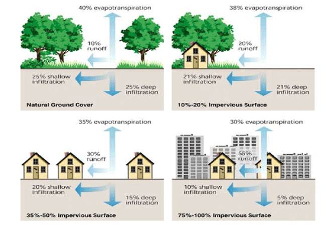
When a drop of water falls inside the watershed, it flows toward the main body of water. It can do this in one of two ways: by soaking into the ground; or by running off the landscape, directly into the waterbody.
If the water soaks into the ground, it becomes part of the groundwater supply, which eventually connects with the surface water. When it goes into the ground, the soils filter out harmful pollutants — things like fertilizer, oil, chemicals, bacteria, trash, etc. — so the water stays clean.
But if the water can’t soak into the ground, it will move toward the lowest point in the landscape, picking up whatever pollutants it finds along the way. This is called runoff, and it’s the largest source of water pollution in the United States.
Imagine a raindrop falling anywhere inside that watershed; no matter where it lands, it will eventually find its way to the main body of water at the bottom. If it lands lands in another watershed, it will drain to a different waterbody.
This short video helps explain the basic concept of a watershed.
How Big is a Watershed?
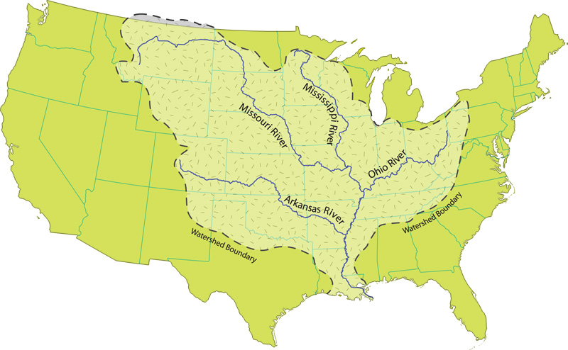
Watersheds can be as small as bathtubs or as big as whole countries. In the United States, a large watershed called the Mississippi River Watershed covers nearly 40 percent of the lower 48 states, stretching from Montana all the way to Pennsylvania. Within that large watershed, many smaller watersheds (often called “subwatersheds”) drain into particular sections of the river — or into other rivers, lakes and groundwater supplies that ultimately connect to the Mississippi.
In Minnesota, there are 80 major watersheds (many of which are part of that larger Mississippi River Watershed). The Twin Cities Metropolitan Area Watershed is divided into 33 smaller watersheds, and the MWMO manages one of these smaller watershed areas. Our 39.9-square mile watershed drains into a section of the river that runs through downtown Minneapolis.
You can explore our watershed boundaries and find out whether you are in the MWMO watershed with our Find Your Watershed feature.
Who Manages Watersheds?
Because watersheds don’t follow political boundaries (such as city and county borders), a variety of organizations help manage and protect our watersheds.
Many cities and counties are involved in managing stormwater, and there are also a variety of special-purpose units of local government who are able to work across city and county boundaries. The MWMO is a “watershed management organization,” which is one such type of government unit. There are also “watershed districts,” “soil and water conservation districts” and others, depending on the needs of the local communities.
The Minnesota Board of Water and Soil Resources (BWSR) is the state agency in charge of overseeing these local land and water protection organizations. You can learn more about the distinctions between different watershed organizations on the BWSR website.
We manage our watershed by monitoring water quality and implementing projects and programs to protect clean water and habitat. You can learn more about the MWMO’s work on our About page and in our Reports section.
Resources
- The Fundamentals of the Water Cycle — U.S. Geological Survey
- Overview of Basic Stormwater Concepts — Minnesota Stormwater Manual
- Mississippi River Facts — U.S. National Park Service
Videos
- The scale of the Mississippi River in perspective — Tech Insider
- Ever wondered where the rain goes? Sustainable drainage animation — Susdrain
- What is a Watershed? (english version) — Missouri and Mississippi Resource Conservation and Development Inc.
- What the Heck is Storm Water Runoff — California Water Boards
- Nature Works – To Make Clean Water — The Nature Conservancy